



Forecast for the Week Ahead
- iwmet service

- 4 hours ago
- 3 min read

A much cooler and rather more changeable week ahead, with plenty of cloud around at times, but also some sunny spells here and there.
There will be a few bits and pieces of rain or the odd shower during the first half of the week, but things look more unsettled during the second half, with a greater chance of rain and showers, some of which could be heavy.
It will also become windier later in the week, with Thursday currently looking like the most unsettled day.
So overall, much cooler, more changeable and finally a bit more in the way of rain!

TOMORROW
A mixture of cloud with some occasional sunny spells developing here and there. There is a chance of the odd shower during the middle of the day and into the afternoon, but most places will remain dry with a mixture of cloud and just occasional sunny spells.
Temperature: 23–24°C, warmest in the northeast and coolest in the west and southwest, where temperatures will be closer to 21–22°C.
Wind: West to northwest, 10–19 mph, becoming west to southwest, 14–25 mph during the afternoon.
Rainfall: 0–1 mm, with localised rainfall possible.

TUESDAY
A lot of cloud around to start the day, with the odd patch of rain possible here and there, although this won’t amount to very much. As we move into the afternoon, we may see a few brighter spells developing, but there will still be quite a bit of cloud floating around.
Temperature: 21°C in the southwest, rising to around 24°C towards the north and east.
Wind: Fresh westerly.
Rainfall: 0–1 mm.
WEDNESDAY
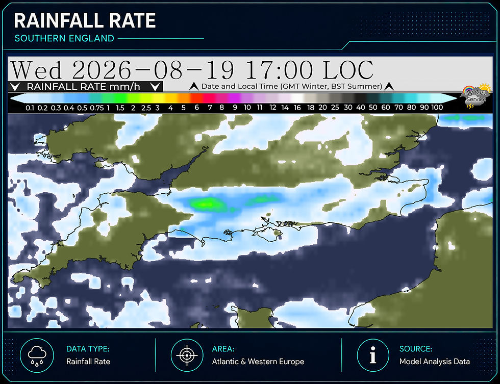
A lot of cloud around to start the day, with perhaps the odd patch of rain here and there, clearing away after what may have been a couple of millimetres falling overnight. Through the daytime, though, we will see a mixture of sunny spells and broken cloud, with more in the way of sunshine developing as we move into the afternoon. There is the outside chance of the odd shower here and there, but most places will miss these.
Temperature: 19–20°C in the south and west, but perhaps as high as 21–22°C in the north and east of the Island.
Wind: Moderate westerly, becoming a fresh west to southwest during the afternoon.
Rainfall: 0–2 mm.

THURSDAY
We potentially see a significant change developing, with the risk of some heavy showers overnight from the previous night. These are likely to stay with us into the morning, with some locally torrential downpours possible for a time during the early hours. As the day goes on, the showers should ease and spread more towards the north and east across the mainland, leaving the Island with less in the way of showers, although the odd one or two may still crop up here and there. Sunny spells will be possible at any point, but the best of these are likely to develop during the afternoon.
Temperature: Around 19°C in the west and southwest, rising to around 21°C towards northern and eastern parts.
Wind: Fresh west to southwest.
Rainfall: 2–8 mm, with locally variable amounts.

FRIDAY
Friday will be a mixed day, with perhaps some early showers clearing to leave sunny spells for a time, before further showers potentially develop during the afternoon. It will feel quite cool, with quite a bit of uncertainty in the details this far out.
Temperature: 19–21°C.
Wind: Moderate westerly, likely turning more northerly later in the day.
Rainfall: Uncertain at this stage.




Comments