

Forecast for the week ahead, July 28th
- iwmet service

- Jul 28, 2024
- 1 min read

Tonight A fine, dry night with little in the way of cloud if any. It will also be less cold than last night with a touch more breeze which will prevent any mist and fog from forming. Temperature 16-17°C but as low as 14°C in a few sheltered rural spots although closer to 19°C around coasts and hills Wind east or east-northeast 7-15mph


Tomorrow
A fine, sunny and very warm day away from windward coasts where it will feel much cooler with a freshening breeze. Temperature 24-26°C but around 20°C on windward coasts Wind east 7-16mph becoming 12-20mph
Level 1 Heat Alert


Tuesday
Another fine day ahead which will feel very warm or even hot in any sunny spells, although there will be increasing amounts of cloud as the day goes on. Feeling much cooler around windward coasts with cooling sea breezes. Temperature 27-29°C but around 22°C on windward coasts Wind northeast 5-11mph but with onshore sea breezes developing.


Wednesday
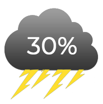
This is where things start to become rather uncertain, but at the moment it looks as though we could see a few thundery showers during the early hours, clearing away during the morning with further thundery rain or showers developing later and overnight. We will have more detail on this tomorrow and on Tuesday. Temperature 22-24°C Wind east 12-18mph


Thursday
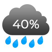
Early thundery rain or showers should clear to give a much cooler, fresher afternoon. Temperature 19-21°C Wind variable 2-6mph becoming west-southwest 15-26mph


Friday
Fresh and breezy with a mixture of cloud and sunny spells with the odd scattered shower. Feeling rather cool. Temperature 19-21°C Wind west-southwest 16-28mph


Comments